Winkelwagen
GT Cycling- and Outdoor Map 1:250.000 / 1:400.000
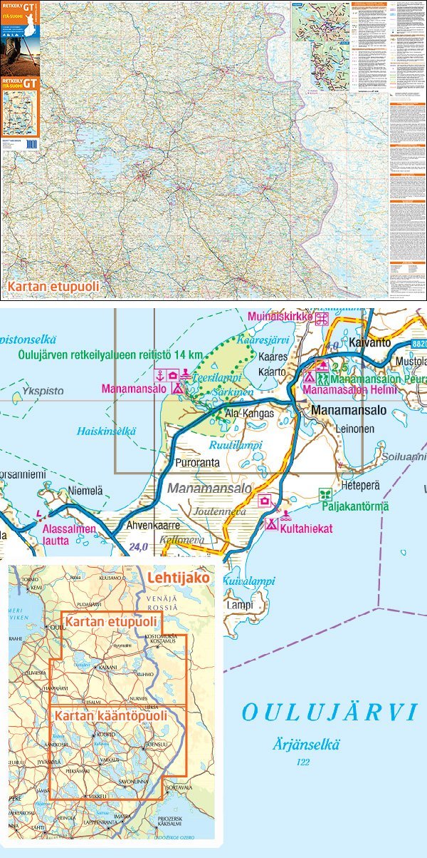
The map offers you a comprehensive, detailed overview of road conditions, hiking, leisure facilities of any kind, landscape conditions and much more in Finland.
Finland has been divided into the following areas:
GT Southfinland (Etelä-Suomi) 1:250.000
GT Westfinland (Länsi-Suomi) 1:250.000
GT Eastfinland (Itä-Suomi) 1:250.000
GT Northfinnland (Pohjois-Suomi) 1:400.000
In addition, the map of selected areas and cities contains detailed plans at a scale of 1:40 000 Further general information for cyclists, hikers and snowmobilers are included.
Legend includes:
Motorway or other dual carriageway, singel carriageway, number of the interchange, other surfaced singel carriageway, unsurfaced roads, private roads, European road, main road, distance in km, moveable bridge, gate, ferries, international car ferry harbour, railway, tunnel, airport, airfield, filling station, servicestation, hotel, motel, youth hostel, holiday village, camping site, rest area, museum, monument, point of interest, nattural formation, point of interest for families, wintersports center, swimming, golf cours, open wilderness hut, day trip hut, reservable hut, rental hut, sauna, dangerous rapids, canoe carrying, nature information center, acces to nature park or trail, canoe route, snowmoble route or trail, national cycling touring route on surfaced, unsurfaced bicicle path or roads, local cycling touring route on surfaced, unsurfaced bicicle path or roads, other cycling path, mountainbike route, EuroVelo route, settlement, storage area, notable builing, masi, view tower, church, lighthouse, field, wooded marsh, open marsh, contour lines
20m, boundaries, National Park, other natural conservation area, public hiking area
Languages: Finish, Swedish, German, English, Russian
current edition
Format: open 119 x 85 cm / folded 11 x 21,5cm, double-side
Geen items in winkelwagen
Ga naar winkelwagen
Fietskaart Itä-Suomi (Finland Oost) Bike map | Karttakeskus (9789522667182)

- ISBN / CODE: 9789522667182
- Editie: 01-10-2022
- Aantal blz.: 1
- Schaal: 1:250000
- Uitgever: Karttakeskus
- Soort: Fietskaart
- Serie: Outdoor bike map
- Taal: Engels, Fins
- Hoogte: 22.0 cm
- Breedte: 10.0 cm
- Gewicht: 116.0 g
- Bindwijze: -
- Uitvoering: Scheur- en watervast
- Schrijf als eerste een review
-
€ 25,95
Uitverkocht, nooit meer leverbaar

Beschrijving
Van de uitgever
A map for trekking in Eastern FinlandGT Cycling- and Outdoor Map 1:250.000 / 1:400.000
The map offers you a comprehensive, detailed overview of road conditions, hiking, leisure facilities of any kind, landscape conditions and much more in Finland.
Finland has been divided into the following areas:
GT Southfinland (Etelä-Suomi) 1:250.000
GT Westfinland (Länsi-Suomi) 1:250.000
GT Eastfinland (Itä-Suomi) 1:250.000
GT Northfinnland (Pohjois-Suomi) 1:400.000
In addition, the map of selected areas and cities contains detailed plans at a scale of 1:40 000 Further general information for cyclists, hikers and snowmobilers are included.
Legend includes:
Motorway or other dual carriageway, singel carriageway, number of the interchange, other surfaced singel carriageway, unsurfaced roads, private roads, European road, main road, distance in km, moveable bridge, gate, ferries, international car ferry harbour, railway, tunnel, airport, airfield, filling station, servicestation, hotel, motel, youth hostel, holiday village, camping site, rest area, museum, monument, point of interest, nattural formation, point of interest for families, wintersports center, swimming, golf cours, open wilderness hut, day trip hut, reservable hut, rental hut, sauna, dangerous rapids, canoe carrying, nature information center, acces to nature park or trail, canoe route, snowmoble route or trail, national cycling touring route on surfaced, unsurfaced bicicle path or roads, local cycling touring route on surfaced, unsurfaced bicicle path or roads, other cycling path, mountainbike route, EuroVelo route, settlement, storage area, notable builing, masi, view tower, church, lighthouse, field, wooded marsh, open marsh, contour lines
20m, boundaries, National Park, other natural conservation area, public hiking area
Languages: Finish, Swedish, German, English, Russian
current edition
Format: open 119 x 85 cm / folded 11 x 21,5cm, double-side
Reviews
Geen reviews gevonden voor dit product.
Schrijf een review
Graag horen wij wat u van dit artikel vindt. Vindt u het goed, leuk, mooi, slecht, lelijk, onbruikbaar of erg handig: schrijf gerust alles op! Het is niet alleen leuk om te doen maar u informeert andere klanten er ook nog mee!
Alle gerelateerde rubrieken >
Ook interessant voor europa/finland/karelie
