Winkelwagen
Geen items in winkelwagen
Ga naar winkelwagen
Kaarten - Centre - Val de Loire
 Wandelkaart - Topografische kaart 2313OT Forêts de Montmorency de l'Isle-Adam et de Carnelle | IGN - Institut Géographique National
 Wandelkaart - Topografische kaart 2214ET Versailles, Forêts de Marly et de St-Germain | IGN - Institut Géographique National
 Wandelkaart - Topografische kaart 2315OT Palaiseau - Arpajon, Forêt de Verrières | IGN - Institut Géographique National
 Wandelkaart - Topografische kaart 2216ET Etampes, Dourdan | IGN - Institut Géographique National
 Wandelkaart - Topografische kaart 2316ET Milly-la-Forêt, Malesherbes, La Ferté-Alais | IGN - Institut Géographique National
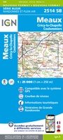 Wandelkaart - Topografische kaart 2514 SB - Serie Bleue Meaux | IGN - Institut Géographique National
 Wandelkaart - Topografische kaart 2614 SB - Serie Bleue La Ferté-Gaucher, Montmirail | IGN - Institut Géographique National
 Wandelkaart - Topografische kaart 2015 SB - Serie Bleue Dreux - Nonancourt | IGN - Institut Géographique National
 Wandelkaart - Topografische kaart 2115 SB - Serie Bleue Epernon | IGN - Institut Géographique National
 Wandelkaart - Topografische kaart 2515 SB - Serie Bleue Mormant, Rozay-en-Brie, Jouy-le-Châtel | IGN - Institut Géographique National
 Wandelkaart - Topografische kaart 2116 SB - Serie Bleue Maintenon | IGN - Institut Géographique National
 Wandelkaart - Topografische kaart 2416 SB - Serie Bleue Melun, Mormant | IGN - Institut Géographique National
 Wandelkaart - Topografische kaart 2516 SB - Serie Bleue Donnemarie-Dontilly, Nangis | IGN - Institut Géographique National
 Wandelkaart - Topografische kaart 2017 SB - Serie Bleue Illiers-Combray, Bailleau-le-Pin | IGN - Institut Géographique National
 Wandelkaart - Topografische kaart 2217 SB - Serie Bleue Méréville - Sainville | IGN - Institut Géographique National
 Wandelkaart - Topografische kaart 2318 SB - Serie Bleue Pithiviers - Puiseaux | IGN - Institut Géographique National
 Wandelkaart - Topografische kaart 2517 SB - Serie Bleue Montereau-Fault-Yonne, Moret-Loing-et-Orvanne | IGN - Institut Géographique National
 Wandelkaart - Topografische kaart 2617 SB - Serie Bleue Bray-sur-Seine | IGN - Institut Géographique National
 Wandelkaart - Topografische kaart 1918 SB - Serie Bleue Authon-du-Perche, La Bazoche-Gouet | IGN - Institut Géographique National
 Topografische kaart - Wandelkaart 2018 SB - Serie Bleue Châteaudun - Brou | IGN - Institut Géographique National
- 1
- 2
- 3
- Volgende >>
- 9
Laatste reviews

Mooie gedetailleerde kaart
We hebben zowel noord als zuid Corsica gekocht. We hebben ze voor onze vakantie in juni nodig en hebben graag een gedetailleerde kaart om te …
★★★★★ door Ruth 12 april 2025 | Heeft dit artikel gekocht
Prima en overzichtelijke kaart.
Fijne kaart vooral ter voorbereiding van onze vakantie op Corsica.
★★★★★ door Ruth 12 april 2025 | Heeft dit artikel gekocht
Gids is ook ideaal als voorbereiding
Met behulp van deze gids hebben we onze fietsreis uitgestippeld. Over ruim een maand gaan we richting Donau en zullen we deze gids zeker nog …
★★★★★ door Jan J. 11 april 2025 | Heeft dit artikel gekocht
Heel duidelijk
Goed
★★★★★ door Schultz 11 april 2025 | Heeft dit artikel gekocht