Winkelwagen
Each island is shown with a trail guide, listing trail start and destination points, distances and difficulty. Trails are mapped with mileage markers and coded according to trail type. Island roads, which can also be used use for hiking, are shown as well. An inset map of the Scorpion Area provides extra detail of this popular area. The map includes contour lines, elevations, labeled peaks, selected waypoints, water features and areas of wooded cover. Moreover, many recreation features and facilities are pinpointed, such as ranger stations, campgrounds, restroom, picnic areas and historic buildings.
Every Trails Illustrated map is printed on "Backcountry Tough" waterproof, tear-resistant paper. A full UTM grid is printed on the map to aid with GPS navigation.
Other features found on this map include: Anacapa Passage, Channel Islands National Park, Encino Reservoir, Franklin Canyon Reservoir, Laguna Point, Point Dume, San Fernando Valley, San Miguel Island, San Miguel Passage, Santa Barbara Island, Santa Cruz Channel, Santa Cruz Island, Santa Monica Mountains, Santa Rosa Island, Sepulveda Dam, Stone Canyon Reservoir.
Geen items in winkelwagen
Ga naar winkelwagen
Wandelkaart 252 Channel Islands National Park | National Geographic (9781566954105)

- ISBN / CODE: 9781566954105
- Editie: 01-01-2019
- Aantal blz.: 1
- Schaal: 1:50000
- Uitgever: National Geographic
- Soort: Wandelkaart
- Serie: Trails Illustrated Topographic Maps
- Taal: Engels
- Hoogte: 24.0 cm
- Breedte: 11.0 cm
- Gewicht: 93.0 g
- Uitvoering: Scheur- en watervast
- Bindwijze: -
- Schrijf als eerste een review
-
€ 17,95
Dit artikel is (tijdelijk) niet leverbaar


-
Overzicht Wandelkaarten California Trails Illustrated National Geographic

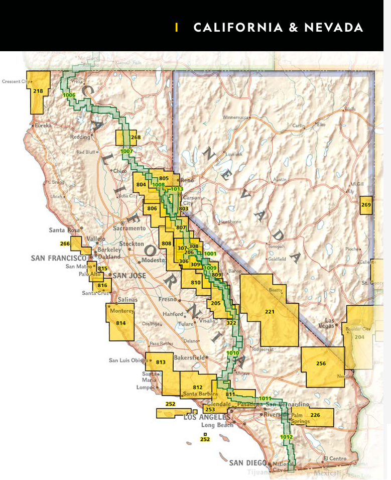
Producten op deze overzichtskaart:
Klik op een product om naar de pagina van dat product te gaan.
- Wandelatlas - Wandelkaart 1001 John Muir Trail | National Geographic
- Wandelkaart 1008 Pacific Crest Trail: Sierra Nevada North | National Geographic
- Wandelkaart - Topografische kaart 205 Sequoia - Kings Canyon National Parks | National Geographic
- Wandelkaart - Topografische kaart 206 Yosemite National Park | National Geographic
- Wandelkaart 218 Redwood National & State Parks | National Geographic
- Wandelkaart - Topografische kaart 221 Trails Illustrated Death Valley National Park | National Geographic
- Wandelkaart - Topografische kaart 226 Joshua Tree National Park | National Geographic
- Wandelkaart 252 Channel Islands National Park | National Geographic
- Wandelkaart - Topografische kaart 256 Mojave National Preserve | National Geographic
- Wandelkaart 268 Lassen Volcanic National Park | National Geographic
- Wandelkaart - Topografische kaart 306 Yosemite SW - Yosemite Valley & Wawona | National Geographic
- Wandelkaart - Topografische kaart 307 Yosemite NW - Hetch Hetchy Reservoir | National Geographic
- Wandelkaart - Topografische kaart 308 Yosemite NE - Tuolumne Meadows and Hoover Wilderness | National Geographic
- Wandelkaart 309 Yosemite SE - Ansel Adams Wilderness | National Geographic
- Wandelkaart - Topografische kaart 803 Lake Tahoe Basin | National Geographic
- Wandelkaart 804 Tahoe National Forest West - Yuba & American Rivers | National Geographic
- Wandelkaart 805 Tahoe National Forest East - Sierra Buttes, Donner Pass | National Geographic
- Wandelkaart - Topografische kaart 809 Mammoth Lakes - Mono Divide - Inyo and Sierra National Forests | National Geographic
- Wandelkaart - Topografische kaart 810 Shaver Lake - Sierra National Forest | National Geographic
- Wandelkaart 811 Angeles National Forest | National Geographic
- Wandelkaart 812 Los Padres National Forest East | National Geographic
- Wandelkaart 814 Big Sur / Ventana Wilderness /CA | National Geographic
Overzichtskaarten
Beschrijving
Van de uitgever
Located just off the California shore, the Channel Islands are home to many unique species of flora and fauna. National Geographic's Trails Illustrated map of Channel Islands National Park covers with unparalleled detail the five islands that encompass the park, including The Nature Conservancy area of Santa Cruz Island and the many State Marine Reserve Areas surrounding the islands. Expertly researched and created in partnership with the National Park Service and others, the map provides background information of the park and of each individual island along with its regulations and guidelines. In addition, information regarding transportation to the islands is given as well as land (hiking), water (swimming, snorkeling and diving) and boating (and kayaking) safety warnings.Each island is shown with a trail guide, listing trail start and destination points, distances and difficulty. Trails are mapped with mileage markers and coded according to trail type. Island roads, which can also be used use for hiking, are shown as well. An inset map of the Scorpion Area provides extra detail of this popular area. The map includes contour lines, elevations, labeled peaks, selected waypoints, water features and areas of wooded cover. Moreover, many recreation features and facilities are pinpointed, such as ranger stations, campgrounds, restroom, picnic areas and historic buildings.
Every Trails Illustrated map is printed on "Backcountry Tough" waterproof, tear-resistant paper. A full UTM grid is printed on the map to aid with GPS navigation.
Other features found on this map include: Anacapa Passage, Channel Islands National Park, Encino Reservoir, Franklin Canyon Reservoir, Laguna Point, Point Dume, San Fernando Valley, San Miguel Island, San Miguel Passage, Santa Barbara Island, Santa Cruz Channel, Santa Cruz Island, Santa Monica Mountains, Santa Rosa Island, Sepulveda Dam, Stone Canyon Reservoir.
Reviews
Geen reviews gevonden voor dit product.
Schrijf een review
Graag horen wij wat u van dit artikel vindt. Vindt u het goed, leuk, mooi, slecht, lelijk, onbruikbaar of erg handig: schrijf gerust alles op! Het is niet alleen leuk om te doen maar u informeert andere klanten er ook nog mee!
Alle gerelateerde rubrieken >
Ook interessant voor noord-amerika/verenigde-staten-van-amerika/californie
-

Reisgids Northern California - Noord
€ 28,95Reisgidsen Californië -

Wandelgids Northern California Hikin
€ 31,95Wandelgidsen Californië -
 | ITMB")
Wegenkaart - landkaart San Francisco
€ 13,95Wegenkaarten San Francisco -

Wandelkaart - Topografische kaart 25
€ 17,95Topografische kaarten Zuidwest USA -

Opruiming - Fotoboek die Welt erlebe
€ 7,50Fotoboeken Zuidwest USA