Wandelkaart 200 Rocky Mountain National Park | National Geographic (9781566953429)
Colorado

- ISBN / CODE: 9781566953429
- Editie: 01-12-2022
- Aantal blz.: 1
- Schaal: 1:50000
- Uitgever: National Geographic
- Soort: Wandelkaart
- Taal: Engels
- Hoogte: 19.0 cm
- Breedte: 10.0 cm
- Gewicht: 95.0 g
- Uitvoering: Scheur- en watervast
- Bindwijze: -
- Beoordeling: 5,0 ★★★★★ (1 review) Schrijf een review
-
€ 16,95
Leverbaar in 3 - 5 werkdagen in huis in Nederland Levertijd Belgie
Gratis verzending in Nederland vanaf €35,-
.jpg)
.jpg)
-
Overzicht Wandelkaarten Colorado Trails Illustrated National Geographic

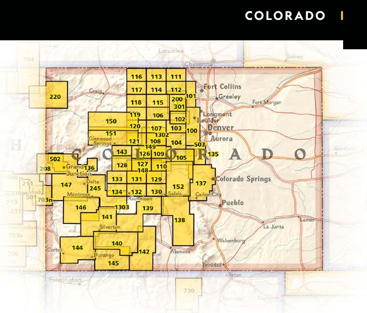
Producten op deze overzichtskaart:
Klik op een product om naar de pagina van dat product te gaan.
- Wandelkaart 103 Winter Park, Central City, Rollins Pass | National Geographic
- Wandelkaart 104 Idaho Springs, Loveland Pass | National Geographic
- Wandelkaart 105 Topographic Map Guide Tarryall Mountains, Kenosha Pass | National Geographic
- Wandelkaart - Topografische kaart 110 Leadville Fairplay | National Geographic
- Wandelkaart 113 Cowdrey, North Sand Hills | National Geographic
- Wandelkaart 119 Yampa, Gore Pass | National Geographic
- Wandelkaart - Topografische kaart 123 Trails Illustrated Flat Tops SE, Glenwood Canyon | National Geographic
- Wandelkaart - Topografische kaart 127 Trails Illustrated Aspen, Independence Pass | National Geographic
- Wandelkaart 131 Crested Butte, Pearl Pass | National Geographic
- Wandelkaart 134 Black Mesa, Curecanti Pass | National Geographic
- Wandelkaart - Topografische kaart 139 Trails Illustrated La Garita, Cochetopa Hills | National Geographic
- Wandelkaart 140 Weminuche Wilderness /CO | National Geographic
- Wandelkaart - Topografische kaart 141 Telluride, Silverton, Ouray, Lake City | National Geographic
- Wandelkaart - Topografische kaart 144 Durango, Cortez | National Geographic
- Wandelkaart - Topografische kaart 146 Uncompahgre Plateau South | National Geographic
- Wandelkaart - Topografische kaart 147 Uncompahgre Plateau North | National Geographic
- Wandelkaart 150 Flat Tops North | National Geographic
- Wandelkaart 151 Flat Tops South | National Geographic
- Wandelkaart 200 Rocky Mountain National Park | National Geographic
- Wandelkaart - Topografische kaart 208 Colorado National Monument | National Geographic
- Wandelkaart - Topografische kaart 245 Black Canyon of the Gunnison National Park | National Geographic
- Wandelkaart 301 Longs Peak / Bear Lake / Wild Basin / Rocky Mountain NP | National Geographic
Overzichtskaarten
Beschrijving
Zeer gedetailleerde wandel- en trekkingkaart voor het Rocky Mountain Nationaal Park in Colorado. Met ingetekende wandelroutes, afstanden, kampeerplekken en toeristische informatie en vele handige tips. GPS geschikt door UTM Grid. Water en scheurvast.
Coverage includes Rocky Mountain National Park, Arapaho and Roosevelt National Forest, Never Summer Wilderness, Arapaho National Recreation Area, and the cities of Granby and Estes Park. Revisions to this map include easy-to-read trail mileage and markers, hiking-only and hike and horse trails are easily distinguished, Federal, State and Private lands are clearly marked, the Continental Divide Trail is highlighted, and the map is keyed to the updated Rocky Mountain National Park Dayhiker's Guide. Includes UTM grids for use with your GPS unit.
Reviews
De wandelkaart Rocky Mountain National Park vond ik wél mooi, een ruim formaat en gedetailleerd, en degene aan wie ik hem cadeau gaf was ook heel tevreden.
★★★★★ door J van der Beek 1 augustus 2023 | Heeft dit artikel gekochtVond u dit een nuttige review? (login om te beoordelen)
Schrijf een review
Graag horen wij wat u van dit artikel vindt. Vindt u het goed, leuk, mooi, slecht, lelijk, onbruikbaar of erg handig: schrijf gerust alles op! Het is niet alleen leuk om te doen maar u informeert andere klanten er ook nog mee!
Ook interessant voor noord-amerika/verenigde-staten-van-amerika/nationale-parken
-

Wandelkaart - Topografische kaart 31
€ 14,95Topografische kaarten Alberta -

Wandelkaart 231 Kenai Fjords Nationa
€ 17,95Wandelkaarten Nationale Parken Verenigde Staten van Amerika -

Wegenkaart - landkaart 3121 United S
€ 17,50Wegenkaarten Rocky Mountains -

Wandelkaart - Topografische kaart 20
€ 16,95Topografische kaarten Nationale Parken Verenigde Staten van Amerika -

Wandelkaart - Topografische kaart 30
€ 14,95Topografische kaarten Nationale Parken Verenigde Staten van Amerika