Winkelwagen
Geen items in winkelwagen
Ga naar winkelwagen
Wandelkaart - Wegenkaart - landkaart 100 Boulder / Golden Trail map - USA | National Geographic (9781566953351)

- ISBN / CODE: 9781566953351
- Editie: 01-12-2023
- Aantal blz.: 1
- Schaal: 1:50000
- Uitgever: National Geographic
- Soort: Wandelkaart, Wegenkaart
- Serie: Trails Illustrated Topographic Maps
- Taal: Engels
- Hoogte: 19.0 cm
- Breedte: 10.0 cm
- Gewicht: 94.0 g
- Uitvoering: Scheur- en watervast
- Bindwijze: -
- Schrijf als eerste een review
-
€ 17,95
Dit artikel is (tijdelijk) niet leverbaar
Beschrijving
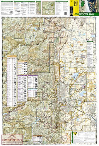
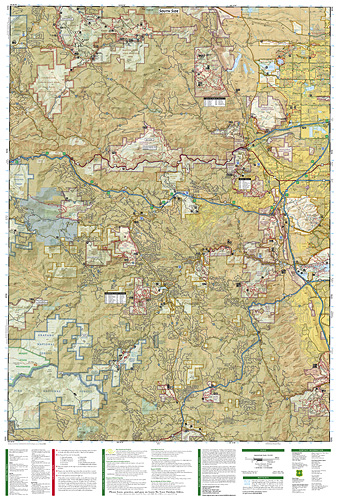
The Boulder/Golden Trails Illustrated map is the most comprehensive recreational map for the northern Colorado Front Range.
Coverage includes Boulder County Open Space Parks, City of Boulder Open Space and Mountain Parks, Jefferson County Open Space Parks, Eldorado and Golden Gate Canyon State Parks, Denver Mountain Parks, Arapaho, Roosevelt and Pike national forests. Also includes Boulder, Golden, Evergreen, Lyons, Lakewood, Morrison, and Aspen Park.
More than just a map, National Geographic Trails Illustrated topographic maps are designed to take you into the wilderness and back. Printed on tear-resistant, waterproof material, this map can go anywhere you do. Each map is based on exact reproductions of USGS topographic map information, updated, customized, and enhanced to meet the unique features of each area. The maps include valuable wilderness tips and Leave No Trace guidelines, along with updated trails, trailheads, points of interest, campgrounds, and much more. With a new color palette and stunning shaded relief, backcountry navigation has never been easier.
Reviews
Geen reviews gevonden voor dit product.
Schrijf een review
Graag horen wij wat u van dit artikel vindt. Vindt u het goed, leuk, mooi, slecht, lelijk, onbruikbaar of erg handig: schrijf gerust alles op! Het is niet alleen leuk om te doen maar u informeert andere klanten er ook nog mee!
Alle gerelateerde rubrieken >
Ook interessant voor noord-amerika/verenigde-staten-van-amerika/noordwest-usa
-

Vogelgids Colorado | Waterford Press
€ 10,95Vogelgidsen Colorado -

Wegenkaart - landkaart 3123 Texas -
€ 17,50Wegenkaarten Oklahoma -

Wegenkaart - landkaart 3122 Northern
€ 17,50Wegenkaarten Middenwesten: West North Central (Great Plains) -

Wandelkaart 137 Topographic Map Guid
€ 17,95Wandelkaarten Colorado -

Wandelkaart - Topografische kaart 13
€ 16,95Topografische kaarten Nationale Parken Verenigde Staten van Amerika