Wandelkaart 822 Mount St. Helens, Mount Adams /WA | National Geographic (9781566955058)

- ISBN / CODE: 9781566955058
- Editie: 01-01-2019
- Aantal blz.: 1
- Schaal: 1:75000
- Uitgever: National Geographic
- Soort: Wandelkaart
- Serie: Trails Illustrated Topographic Maps
- Taal: Engels
- Hoogte: 19.0 cm
- Breedte: 10.0 cm
- Gewicht: 91.0 g
- Uitvoering: Scheur- en watervast
- Bindwijze: -
- Schrijf als eerste een review
-
€ 17,95
Leverbaar in 3 - 5 werkdagen in huis in Nederland Levertijd Belgie
Gratis verzending in Nederland vanaf €35,-


-
Overzicht Wandelkaarten Washington Trails Illustrated National Geographic

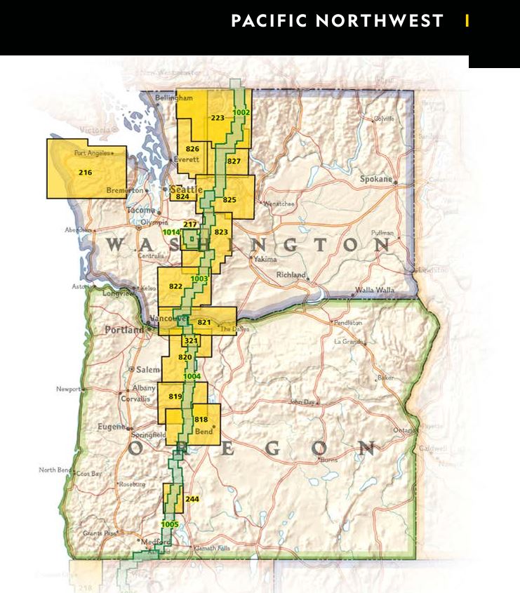
Producten op deze overzichtskaart:
Klik op een product om naar de pagina van dat product te gaan.
- Wandelkaart 216 Olympic National Park | National Geographic
- Wandelkaart - Topografische kaart 217 Mount Rainier National Park | National Geographic
- Wandelkaart 223 North Cascades National Park | National Geographic
- Wandelkaart 244 Crater Lake National Park | National Geographic
- Wandelkaart 321 Mount Hood Wilderness - Mount Hood National Forest ng r/v wp /OR | National Geographic
- Wandelkaart 818 Bend, Three Sisters /OR | National Geographic
- Wandelkaart 819 Mount Jefferson, Mount Washington /OR | National Geographic
- Wandelkaart - Topografische kaart 820 Mount Hood and Willamette National Forests | National Geographic
- Wandelkaart - Topografische kaart 821 Columbia River Gorge National Scenic Area | National Geographic
- Wandelkaart 822 Mount St. Helens, Mount Adams /WA | National Geographic
- Wandelkaart 825 Alpine Lakes Wilderness /WA | National Geographic
- Wandelkaart 826 Topographic Map Guide Mount Baker & Boulder River Wilderness /WA | National Geographic
Overzichtskaarten
Beschrijving
Van de uitgever
Mount St. Helens is an active volcano in Washington's Cascade Range. Neighboring peak Mount Adams is the second highest summit in Washington after Mount Ranier. Explore the beauty and geological wonder of these magnificent mountains with National Geographic's Trails Illustrated map of Mount St. Helens, Mount Adams. Created in partnership with local land management agencies, this expertly researched map features key areas of interest including Mount St. Helens National Volcanic Monument; Trapper Creek Wilderness; Swift Reservoir; Salmon, Cispus, and Lewis rivers; and Yale, Coldwater, and Spirit lakes.This map can guide you off the beaten path and back again with miles of mapped trails including a portion of the Pacific Crest National Scenic Trail. Helpful information on Mount Margaret, Indian Heaven Wilderness, climbing Mount St. Helens, mountain safety tips and more will prove invaluable in your exploration of the region. Many recreation features are noted as well, including interpretive trails, campgrounds, ATV trails, sno-parks, cross country ski trails, and horse camps.
Every Trails Illustrated map is printed on "Backcountry Tough" waterproof, tear-resistant paper. A full UTM grid is printed on the map to aid with GPS navigation.
Other features found on this map include: Bare Mountain, Gifford Pinchot National Forest, Goat Rocks Wilderness, Indian Heaven Wilderness, Little Huckleberry Mountain, McCoy Peak, Mount Adams, Mount Adams Wilderness, Mount Saint Helens, Spirit Lake, Swift Reservoir, Trout Lake, Yale Lake.
Reviews
Geen reviews gevonden voor dit product.
Schrijf een review
Graag horen wij wat u van dit artikel vindt. Vindt u het goed, leuk, mooi, slecht, lelijk, onbruikbaar of erg handig: schrijf gerust alles op! Het is niet alleen leuk om te doen maar u informeert andere klanten er ook nog mee!
Ook interessant voor noord-amerika/verenigde-staten-van-amerika/noordwestelijke-vs-pacific/washington-staat
-

Reisgids 111 places in Places in Sea
€ 19,95Reisgidsen Noordwest USA -

Vogelgids Sibley Field Guide to Bird
€ 25,95Vogelgidsen Alberta -

Wegenkaart - landkaart State Guide M
€ 12,95Wegenkaarten Washington (staat) -

Wandelgids Pacific Northwest Hiking
€ 27,95Wandelgidsen Oregon -

Wandelkaart Pacific Crest Trail | IT
€ 13,95Wandelkaarten Washington (staat)