Wandelkaart 819 Mount Jefferson, Mount Washington /OR | National Geographic (9781566956635)

- ISBN / CODE: 9781566956635
- Editie: 01-01-2019
- Aantal blz.: 1
- Schaal: 1:75000
- Uitgever: National Geographic
- Soort: Wandelkaart
- Serie: Trails Illustrated Topographic Maps
- Taal: Engels
- Hoogte: 24.0 cm
- Breedte: 11.0 cm
- Gewicht: 95.0 g
- Uitvoering: Scheur- en watervast
- Bindwijze: -
- Schrijf als eerste een review
-
€ 17,95
Dit artikel is (tijdelijk) niet leverbaar


-
Overzicht Wandelkaarten Washington Trails Illustrated National Geographic

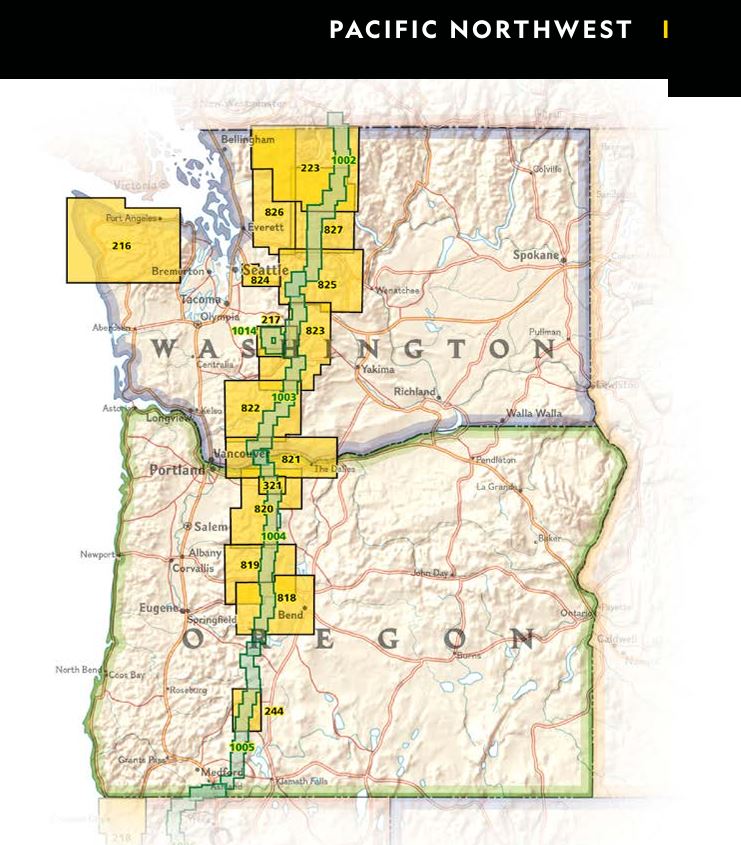
Producten op deze overzichtskaart:
Klik op een product om naar de pagina van dat product te gaan.
- Wandelkaart 216 Olympic National Park | National Geographic
- Wandelkaart - Topografische kaart 217 Mount Rainier National Park | National Geographic
- Wandelkaart 223 North Cascades National Park | National Geographic
- Wandelkaart 244 Crater Lake National Park | National Geographic
- Wandelkaart 321 Mount Hood Wilderness - Mount Hood National Forest ng r/v wp /OR | National Geographic
- Wandelkaart 818 Bend, Three Sisters /OR | National Geographic
- Wandelkaart 819 Mount Jefferson, Mount Washington /OR | National Geographic
- Wandelkaart - Topografische kaart 820 Mount Hood and Willamette National Forests | National Geographic
- Wandelkaart - Topografische kaart 821 Columbia River Gorge National Scenic Area | National Geographic
- Wandelkaart 822 Mount St. Helens, Mount Adams /WA | National Geographic
- Wandelkaart 825 Alpine Lakes Wilderness /WA | National Geographic
- Wandelkaart 826 Topographic Map Guide Mount Baker & Boulder River Wilderness /WA | National Geographic
Overzichtskaarten
Beschrijving
Van de uitgever
The Mount Jefferson and Mount Washington Wilderness Areas are characterized by picturesque mountains, glaciers, alpine meadows, pine and fir forests, and over 175 lakes. National Geographic's Trails Illustrated map of Mount Jefferson and Mount Washington combines unmatched detail with helpful information to offer an invaluable tool for making the most of your visit to the High Cascades. Expertly researched and created in partnership with local land management agencies, this map features key points of interest including Menagerie Wilderness; Detroit, Suttle, Clear, Marion, and Blue River lakes; McKenzie and Metolius rivers; and Santiam Pass Summer OHV Area.
With hundreds of miles of mapped trails including portions of the Pacific Crest National Scenic Trail, Metolius-Windigo Trail, Lava River National Recreation Trail, this map can guide you off the beaten path and back again. Trail use is easy to identify, whether you're hiking, biking, horseback riding, or OHVing. The McKenzie Pass, Santiam Pass and West Cascades scenic byways are noted for those wishing to take in the scenery by car. Many recreation features are noted as well, including campgrounds, horse camps, boat ramps, water ski and swimming areas, whitewater access, ski areas, sno-parks, interpretive sites, and points of interest. The map base includes contour lines and elevations for summits and passes.
Every Trails Illustrated map is printed on "Backcountry Tough" waterproof, tear-resistant paper. A full UTM grid is printed on the map to aid with GPS navigation.
Other features found on this map include: Black Butte, Cougar Reservoir, Deschutes National Forest, Detroit Lake, Green Ridge, Middle Santiam Wilderness, Mount Jefferson, Mount Jefferson Wilderness, Mount Washington Wilderness, Three Sisters Wilderness, Willamette National Forest.
Reviews
Geen reviews gevonden voor dit product.
Schrijf een review
Graag horen wij wat u van dit artikel vindt. Vindt u het goed, leuk, mooi, slecht, lelijk, onbruikbaar of erg handig: schrijf gerust alles op! Het is niet alleen leuk om te doen maar u informeert andere klanten er ook nog mee!
Ook interessant voor noord-amerika/verenigde-staten-van-amerika/oregon
-

Vogelgids Sibley Field Guide to Bird
€ 25,95Vogelgidsen Alberta -

Wandelkaart 244 Crater Lake National
€ 17,95Wandelkaarten Nationale Parken Verenigde Staten van Amerika -

Reisverhaal Alleen - De Pacific Cres
€ 24,99Reisverhalen Westelijke VS: Pacific -

Wegenkaart - landkaart USA Pacific C
€ 13,95Wegenkaarten Washington (staat) -

Reisgids Coastal Oregon | Moon Trave
€ 20,95Reisgidsen Oregon