Winkelwagen
With extensive detail of Longs Peak and miles of clearly marked trails, scenic byways lakes and creeks, the map can guide you off the beaten path and back again. The clearly marked trails include mileages between intersections. The map base includes contour lines and elevations for summits and passes. Some of the many recreation features include: visitor centers, campgrounds, backcountry campsites, trailheads, and interpretive trails.
Every Trails Illustrated map is printed on "Backcountry Tough" waterproof, tear-resistant paper. A full UTM grid is printed on the map to aid with GPS navigation.
Other features found on this map include: Longs Peak, Rocky Mountain National Park, Roosevelt National Forest.
Geen items in winkelwagen
Ga naar winkelwagen
Wandelkaart 301 Longs Peak / Bear Lake / Wild Basin / Rocky Mountain NP | National Geographic (9781566954310)

- ISBN / CODE: 9781566954310
- Editie: 01-01-2019
- Aantal blz.: 1
- Schaal: 1:25000
- Uitgever: National Geographic
- Soort: Wandelkaart
- Serie: Trails Illustrated Topographic Maps
- Taal: Engels
- Hoogte: 19.0 cm
- Breedte: 10.0 cm
- Gewicht: 91.0 g
- Uitvoering: Scheur- en watervast
- Bindwijze: -
- Schrijf als eerste een review
-
€ 17,95
Dit artikel is (tijdelijk) niet leverbaar
-
Overzicht Wandelkaarten Colorado Trails Illustrated National Geographic

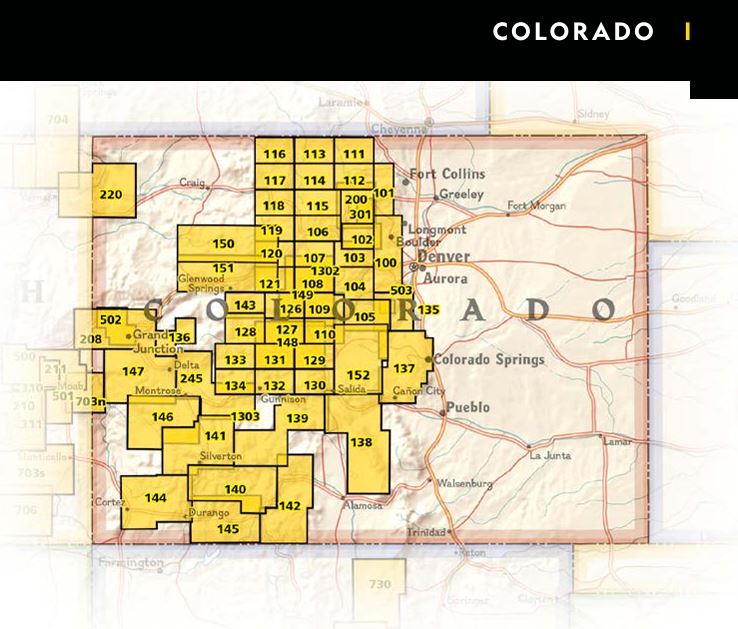
Producten op deze overzichtskaart:
Klik op een product om naar de pagina van dat product te gaan.
- Wandelkaart 103 Winter Park, Central City, Rollins Pass | National Geographic
- Wandelkaart 104 Idaho Springs, Loveland Pass | National Geographic
- Wandelkaart 105 Topographic Map Guide Tarryall Mountains, Kenosha Pass | National Geographic
- Wandelkaart - Topografische kaart 110 Leadville Fairplay | National Geographic
- Wandelkaart 113 Cowdrey, North Sand Hills | National Geographic
- Wandelkaart 119 Yampa, Gore Pass | National Geographic
- Wandelkaart - Topografische kaart 123 Trails Illustrated Flat Tops SE, Glenwood Canyon | National Geographic
- Wandelkaart - Topografische kaart 127 Trails Illustrated Aspen, Independence Pass | National Geographic
- Wandelkaart 131 Crested Butte, Pearl Pass | National Geographic
- Wandelkaart 134 Black Mesa, Curecanti Pass | National Geographic
- Wandelkaart - Topografische kaart 139 Trails Illustrated La Garita, Cochetopa Hills | National Geographic
- Wandelkaart 140 Weminuche Wilderness /CO | National Geographic
- Wandelkaart - Topografische kaart 141 Telluride, Silverton, Ouray, Lake City | National Geographic
- Wandelkaart - Topografische kaart 144 Durango, Cortez | National Geographic
- Wandelkaart - Topografische kaart 146 Uncompahgre Plateau South | National Geographic
- Wandelkaart - Topografische kaart 147 Uncompahgre Plateau North | National Geographic
- Wandelkaart 150 Flat Tops North | National Geographic
- Wandelkaart 151 Flat Tops South | National Geographic
- Wandelkaart 200 Rocky Mountain National Park | National Geographic
- Wandelkaart - Topografische kaart 208 Colorado National Monument | National Geographic
- Wandelkaart - Topografische kaart 245 Black Canyon of the Gunnison National Park | National Geographic
- Wandelkaart 301 Longs Peak / Bear Lake / Wild Basin / Rocky Mountain NP | National Geographic
Overzichtskaarten
Beschrijving
Van de uitgever
Towering over the Rocky Mountains stands the 14,259 foot high Longs Peak. National Geographic's Trails Illustrated map of Longs Peak and the surrounding south-east areas of Rocky Mountain National Park is designed to meet the needs of those who are looking for a phenomenal climbing experience as well as for all outdoor enthusiasts. Expertly researched and created in partnership with local land management agencies, this map features key points of interest including Bear Lake, Wild Basin, Moraine Park , Glacier Basin, the privately owned MacGregor Ranch Conservation Easement and the western edge of the Roosevelt National Forest.With extensive detail of Longs Peak and miles of clearly marked trails, scenic byways lakes and creeks, the map can guide you off the beaten path and back again. The clearly marked trails include mileages between intersections. The map base includes contour lines and elevations for summits and passes. Some of the many recreation features include: visitor centers, campgrounds, backcountry campsites, trailheads, and interpretive trails.
Every Trails Illustrated map is printed on "Backcountry Tough" waterproof, tear-resistant paper. A full UTM grid is printed on the map to aid with GPS navigation.
Other features found on this map include: Longs Peak, Rocky Mountain National Park, Roosevelt National Forest.
Reviews
Geen reviews gevonden voor dit product.
Schrijf een review
Graag horen wij wat u van dit artikel vindt. Vindt u het goed, leuk, mooi, slecht, lelijk, onbruikbaar of erg handig: schrijf gerust alles op! Het is niet alleen leuk om te doen maar u informeert andere klanten er ook nog mee!
Alle gerelateerde rubrieken >
Ook interessant voor noord-amerika/verenigde-staten-van-amerika/rocky-mountain-nationaal-park
-

Wegenkaart - landkaart 175 Four Corn
€ 10,95Wegenkaarten Zuidwest USA -

Reisgids California - Southwest USA'
€ 18,50Reisgidsen Zuidwest USA -

Wandelkaart 138 Trails Illustrated G
€ 16,95Wandelkaarten Nationale Parken Verenigde Staten van Amerika -

Legpuzzel Crystal Mill - Colorado -
€ 18,95Legpuzzels - 1000 stukjes Colorado -

Vogelgids - Natuurgids Rocky Mountai
€ 10,95Natuurgidsen Rocky Mountains