Winkelwagen
Geen items in winkelwagen
Ga naar winkelwagen
Topografische kaarten - Poitou-Charentes
 Wandelkaart - Topografische kaart 1724 SB - Serie Bleue Loudun – Richelieu | IGN - Institut Géographique National★★★★★
 Wandelkaart - Topografische kaart 1926 SB - Serie Bleue Le Blanc, Pleumartin, La Roche-Posay | IGN - Institut Géographique National
 Wandelkaart - Topografische kaart 1425 SB - Serie Bleue Les Herbiers | IGN - Institut Géographique National
 Topografische kaart - Wandelkaart 1525 SB - Serie Bleue Bressuire | IGN - Institut Géographique National
 Topografische kaart - Wandelkaart 1625 SB - Serie Bleue Thouars | IGN - Institut Géographique National
 Wandelkaart - Topografische kaart 1526 SB - Serie Bleue Moncoutant - La Chapelle-Saint-Laurent | IGN - Institut Géographique National
 Wandelkaart - Topografische kaart 1428 SB - Serie Bleue Marans | IGN - Institut Géographique National
 Wandelkaart - Topografische kaart 1927 SB - Serie Bleue La Trimouille | IGN - Institut Géographique National
 Wandelkaart - Topografische kaart 1928 SB - Serie Bleue Montmorillon, Lathus-St-Rémy | IGN - Institut Géographique National
 Wandelkaart - Topografische kaart 1830 SB - Serie Bleue Confolens | IGN - Institut Géographique National
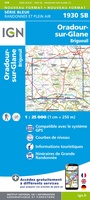 Wandelkaart - Topografische kaart 1930 SB - Serie Bleue Oradour-sur-Glane | IGN - Institut Géographique National
 Wandelkaart - Topografische kaart 1831 SB - Serie Bleue Rochefoucauld - Exideuil | IGN - Institut Géographique National
 Wandelkaart - Topografische kaart 1832 SB - Serie Bleue Montbron, Piégut-Pluviers | IGN - Institut Géographique National★★★★★
 Wandelkaart - Topografische kaart 1733 SB - Serie Bleue Montmoreau-Saint-Cybard | IGN - Institut Géographique National
 Wandelkaart - Topografische kaart 1530 SB - Serie Bleue Saint-Jean-d'Angély | IGN - Institut Géographique National
 Wandelkaart - Topografische kaart 1531 SB - Serie Bleue Saintes - Burie | IGN - Institut Géographique National
 Wandelkaart - Topografische kaart 1329ET La Rochelle - Anse de l'Aiguillon | IGN - Institut Géographique National
 Wandelkaart - Topografische kaart 1329OT Ile De Re | IGN - Institut Géographique National
 Wandelkaart - Topografische kaart 1330OT Ile d'Oleron & Ile d'Aix | IGN - Institut Géographique National
 Wandelkaart - Topografische kaart 1332ET Royan - Foret de la Coubre | IGN - Institut Géographique National
Laatste reviews

Zeer tevreden
Zowel over de prachtige collectie wandelgidsen-boeken en-kaarten als de afhandeling van mijn bestellingen ben ik zeer tevreden.
★★★★★ door Anja van Kooten Niekerk 15 april 2025 | Heeft dit artikel gekocht
Zeer tevreden
Zowel over de prachtige collectie wandelgidsen-boeken en-kaarten als de afhandeling van mijn bestellingen ben ik zeer tevreden.
★★★★★ door Anja van Kooten `Niekerk 15 april 2025 | Heeft dit artikel gekocht
Goed naslagwerk voor op reis
Ik kende van deze uitgever al andere reisgidsen. Daarom deze gekozen. Maar wel jammer dat ie niet in het NederlNDS IS, LEEST TOCH MAKKELIJKER
★★★★★ door Maarten 15 april 2025 | Heeft dit artikel gekocht
Mooie detaillering van de binnen wegen
Deze schaal heeft altijd mijn voorkeur omdat je heel goed een route over binnenwegen kunt uitstippelen
★★★★★ door Maarten 15 april 2025 | Heeft dit artikel gekocht