Winkelwagen
Geen items in winkelwagen
Ga naar winkelwagen
Topografische kaarten - Mercantour
Overzichtskaarten
-
Topografische kaarten IGN 25.000 Mercantour - Noordelijke Provence

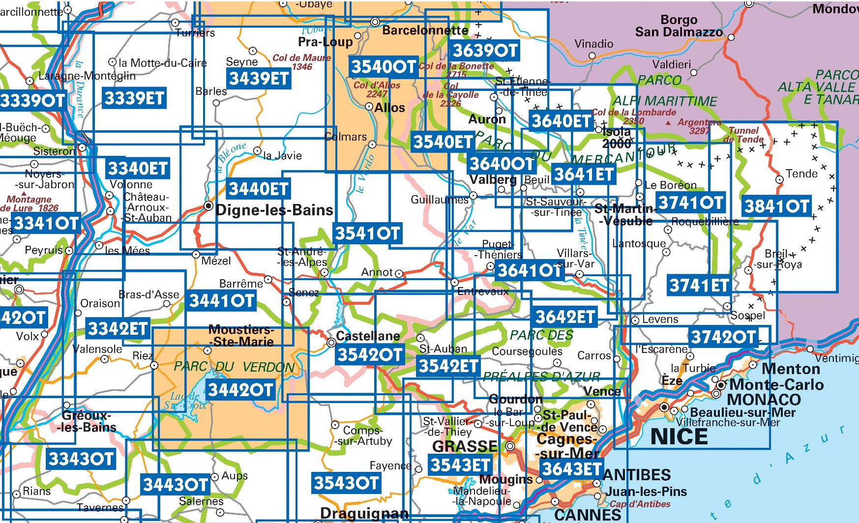
Producten op deze overzichtskaart:
Klik op een product om naar de pagina van dat product te gaan.
- Wandelkaart - Topografische kaart 3243OT Pertuis - Lourmarin | IGN - Institut Géographique National
- Wandelkaart - Topografische kaart 3339ET la Motte-du-Caire | IGN - Institut Géographique National
- Wandelkaart - Topografische kaart 3340ET Digne-les-Bains | IGN - Institut Géographique National
- Wandelkaart - Topografische kaart 3342ET Plateau de Valensole | IGN - Institut Géographique National
- Wandelkaart - Topografische kaart 3342OT Manosque - Forcalquier | IGN - Institut Géographique National
- Wandelkaart - Topografische kaart 3343OT Gréoux-les-Bains - Rians | IGN - Institut Géographique National
- Wandelkaart - Topografische kaart 3439ET Seyne | IGN - Institut Géographique National
- Topografische kaart - Wandelkaart 3440ET Digne-les-Bains | IGN - Institut Géographique National
- Wandelkaart - Topografische kaart 3441OT Barrême | IGN - Institut Géographique National
- Wandelkaart - Topografische kaart 3442OT Gorges du Verdon | IGN - Institut Géographique National
- Wandelkaart - Topografische kaart 3540ET Haute Vallée du Var | IGN - Institut Géographique National
- Wandelkaart - Topografische kaart 3540OT Barcelonnette | IGN - Institut Géographique National
- Wandelkaart - Topografische kaart 3541OT Annot | IGN - Institut Géographique National
- Wandelkaart - Topografische kaart 3542ET Haute Estéron | IGN - Institut Géographique National
- Wandelkaart - Topografische kaart 3542OT Castellane | IGN - Institut Géographique National
- Wandelkaart - Topografische kaart 3639OT Haute Tinée 1 | IGN - Institut Géographique National
- Wandelkaart - Topografische kaart 3640ET Haute Tinée 2 | IGN - Institut Géographique National
- Wandelkaart - Topografische kaart 3640OT Haut Cians | IGN - Institut Géographique National
- Wandelkaart - Topografische kaart 3641ET Moyenne Tinée | IGN - Institut Géographique National
- Wandelkaart - Topografische kaart 3641OT Moyen Var | IGN - Institut Géographique National
- Wandelkaart - Topografische kaart 3642ET Vallée de l'Esteron | IGN - Institut Géographique National
- Wandelkaart - Topografische kaart 3741ET Vallée de la Bévera | IGN - Institut Géographique National
- Wandelkaart - Topografische kaart 3741OT Vallée de la Vesubie | IGN - Institut Géographique National
- Wandelkaart - Topografische kaart 3841OT Vallée de la Roya | IGN - Institut Géographique National
 Wandelkaart - Topografische kaart 3339ET la Motte-du-Caire | IGN - Institut Géographique National
 Wandelkaart - Topografische kaart 3340ET Digne-les-Bains | IGN - Institut Géographique National
 Wandelkaart - Topografische kaart 3342ET Plateau de Valensole | IGN - Institut Géographique National
 Wandelkaart - Topografische kaart 3343OT Gréoux-les-Bains - Rians | IGN - Institut Géographique National
 Wandelkaart - Topografische kaart 3439ET Seyne | IGN - Institut Géographique National
 Topografische kaart - Wandelkaart 3440ET Digne-les-Bains | IGN - Institut Géographique National★★★★★
 Wandelkaart - Topografische kaart 3441OT Barrême | IGN - Institut Géographique National
 Wandelkaart - Topografische kaart 3442OT Gorges du Verdon | IGN - Institut Géographique National
 Wandelkaart - Topografische kaart 3242OT Apt | IGN - Institut Géographique National
 Wandelkaart - Topografische kaart 3540ET Haute Vallée du Var | IGN - Institut Géographique National★★★★★
 Wandelkaart - Topografische kaart 3540OT Barcelonnette | IGN - Institut Géographique National
 Wandelkaart - Topografische kaart 3541OT Annot | IGN - Institut Géographique National
 Wandelkaart - Topografische kaart 3542ET Haute Estéron | IGN - Institut Géographique National
 Wandelkaart - Topografische kaart 3542OT Castellane | IGN - Institut Géographique National
 Wandelkaart - Topografische kaart 3639OT Haute Tinée 1 | IGN - Institut Géographique National
 Wandelkaart - Topografische kaart 3640ET Haute Tinée 2 | IGN - Institut Géographique National
 Wandelkaart - Topografische kaart 3640OT Haut Cians | IGN - Institut Géographique National
 Wandelkaart - Topografische kaart 3641ET Moyenne Tinée | IGN - Institut Géographique National
 Wandelkaart - Topografische kaart 3641OT Moyen Var | IGN - Institut Géographique National
 Wandelkaart - Topografische kaart 3642ET Vallée de l'Esteron | IGN - Institut Géographique National
Laatste reviews

Prachtig getekend
De ontvanger van dit cadeau is er erg blij mee. De Zwerver heeft het mooi naar het cadeaukaarten verstuurd. Er wordt vaak mee gespeeld.
★★★★★ door Carola 26 december 2025 | Heeft dit artikel gekocht
Geweldig
Super gedetailleerde kaart met alle routes en wandelroutes. Ik ben er blij mee.
★★★★★ door Rob 26 december 2025 | Heeft dit artikel gekocht
fijne atlas met duidelijke kaarten
Zeer gedetaillerd, fijn groot formaat atlas voor reizen met auto of camper. Niet geschikt voor backpackers want groot en vrij zwaar.
★★★★★ door Inge Hens 23 december 2025 | Heeft dit artikel gekocht
Goed ontvangen
Ik heb iemand met Sinterklaas héél blij gemaakt met de kaarten. Hij kon er niet genoeg van krijgen en gaf geregeld aan dat hij verheugd …
★★★★★ door Peet Maessen 23 december 2025 | Heeft dit artikel gekocht