Winkelwagen
Geen items in winkelwagen
Ga naar winkelwagen
Topografische kaarten - Provence
Overzichtskaarten
-
Topografische kaarten IGN 25.000 Provence en Cote d'Azur - WESTELIJK GEDEELTE
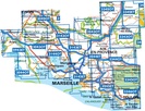
Producten op deze overzichtskaart:
Klik op een product om naar de pagina van dat product te gaan.
- Wandelkaart - Topografische kaart 2943ET Arles | IGN - Institut Géographique National
- Wandelkaart - Topografische kaart 3042OT Saint-Rémy-de-Provence | IGN - Institut Géographique National
- Topografische kaart - Wandelkaart 3043OT Saint-Martin-de-Crau | IGN - Institut Géographique National
- Wandelkaart - Topografische kaart 3044OT Port-Saint-Louis-du-Rhône | IGN - Institut Géographique National
- Wandelkaart - Topografische kaart 3143ET Aix-en-Provence | IGN - Institut Géographique National
- Wandelkaart - Topografische kaart 3143OT Salon-de-Provence | IGN - Institut Géographique National
- Wandelkaart - Topografische kaart 3144OT Étang de Berre | IGN - Institut Géographique National
- Wandelkaart - Topografische kaart 3243OT Pertuis - Lourmarin | IGN - Institut Géographique National
- Wandelkaart - Topografische kaart 3244ET Montagne - Sainte-Victoire | IGN - Institut Géographique National
- Topografische kaart - Wandelkaart 3245ET Aubagne - La Ciotat | IGN - Institut Géographique National
- Wandelkaart - Topografische kaart 3342ET Plateau de Valensole | IGN - Institut Géographique National
- Wandelkaart - Topografische kaart 3342OT Manosque - Forcalquier | IGN - Institut Géographique National
- Wandelkaart - Topografische kaart 3343OT Gréoux-les-Bains - Rians | IGN - Institut Géographique National
- Wandelkaart - Topografische kaart 3344OT Saint-Maximin-la-Sainte-Baume | IGN - Institut Géographique National
- Wandelkaart - Topografische kaart 3345OT Signes – Tourves | IGN - Institut Géographique National
- Wandelkaart - Topografische kaart 3346OT Toulon | IGN - Institut Géographique National
-
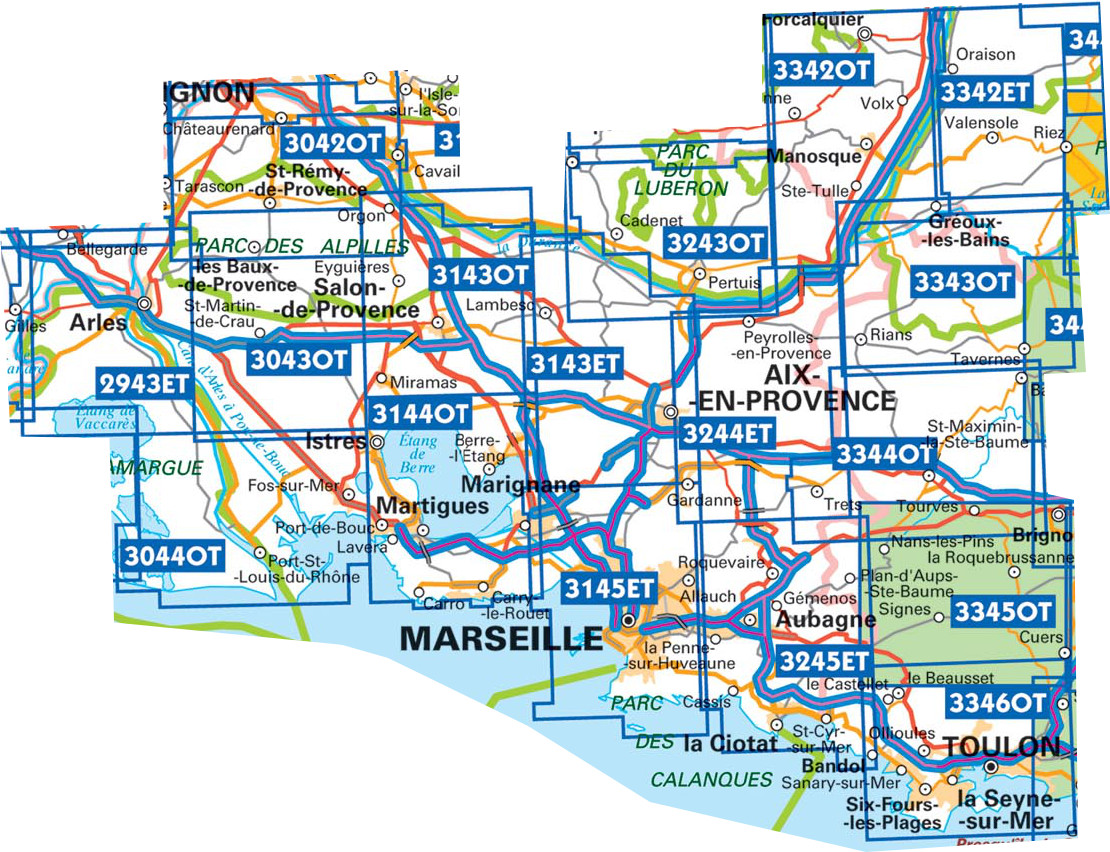
Topografische kaarten IGN 25.000 Provence en Cote d'Azur - OOSTELIJK GEDEELTE


Producten op deze overzichtskaart:
Klik op een product om naar de pagina van dat product te gaan.
- Wandelkaart - Topografische kaart 3442OT Gorges du Verdon | IGN - Institut Géographique National
- Wandelkaart - Topografische kaart 3443OT Aups | IGN - Institut Géographique National
- Wandelkaart - Topografische kaart 3444OT Brignoles - le Luc | IGN - Institut Géographique National
- Wandelkaart - Topografische kaart 3445OT Cuers | IGN - Institut Géographique National
- Wandelkaart - Topografische kaart 3446ET Le Lavandou | IGN - Institut Géographique National
- Wandelkaart - Topografische kaart 3446OT Hyères | IGN - Institut Géographique National
- Wandelkaart - Topografische kaart 3542ET Haute Estéron | IGN - Institut Géographique National
- Wandelkaart - Topografische kaart 3542OT Castellane | IGN - Institut Géographique National
- Wandelkaart - Topografische kaart 3543ET Haute Siagne | IGN - Institut Géographique National
- Wandelkaart - Topografische kaart 3543OT Draguignan | IGN - Institut Géographique National
- Topografische kaart - Wandelkaart 3544ET Fréjus - Saint-Raphaël | IGN - Institut Géographique National
- Wandelkaart - Topografische kaart 3545OT Saint-Tropez - Sainte-Maxime | IGN - Institut Géographique National
- Wandelkaart - Topografische kaart 3641OT Moyen Var | IGN - Institut Géographique National
- Wandelkaart - Topografische kaart 3642ET Vallée de l'Esteron | IGN - Institut Géographique National
- Wandelkaart - Topografische kaart 3741ET Vallée de la Bévera | IGN - Institut Géographique National
 Wandelkaart - Topografische kaart 3741ET Vallée de la Bévera | IGN - Institut Géographique National★★★★★
 Wandelkaart - Topografische kaart 3841OT Vallée de la Roya | IGN - Institut Géographique National★★★★★
 Wandelkaart - Topografische kaart 3641OT Moyen Var | IGN - Institut Géographique National
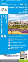 Wandelkaart - Topografische kaart 3342ET Plateau de Valensole | IGN - Institut Géographique National
 Wandelkaart - Topografische kaart 3244ET Montagne - Sainte-Victoire | IGN - Institut Géographique National★★★★★
 Topografische kaart - Wandelkaart 3245ET Aubagne - La Ciotat | IGN - Institut Géographique National★★★★★
 Wandelkaart - Topografische kaart 3344OT Saint-Maximin-la-Sainte-Baume | IGN - Institut Géographique National
 Wandelkaart - Topografische kaart 3345OT Signes – Tourves | IGN - Institut Géographique National
 Wandelkaart - Topografische kaart 3346OT Toulon | IGN - Institut Géographique National
 Wandelkaart - Topografische kaart 3443OT Aups | IGN - Institut Géographique National
 Wandelkaart - Topografische kaart 3444OT Brignoles - le Luc | IGN - Institut Géographique National
 Wandelkaart - Topografische kaart 3445OT Cuers | IGN - Institut Géographique National
 Wandelkaart - Topografische kaart 3446OT Hyères | IGN - Institut Géographique National
 Wandelkaart - Topografische kaart 3446ET Le Lavandou | IGN - Institut Géographique National
 Wandelkaart - Topografische kaart 3545OT Saint-Tropez - Sainte-Maxime | IGN - Institut Géographique National
 Topografische kaart - Wandelkaart 3544ET Fréjus - Saint-Raphaël | IGN - Institut Géographique National★★★★★
 Wandelkaart - Topografische kaart 3543ET Haute Siagne | IGN - Institut Géographique National★★★★★
 Wandelkaart - Topografische kaart 3143ET Aix-en-Provence | IGN - Institut Géographique National
 Wandelkaart - Topografische kaart 3243OT Pertuis - Lourmarin | IGN - Institut Géographique National★★★★★
 Wandelkaart - Topografische kaart 3342OT Manosque - Forcalquier | IGN - Institut Géographique National
Laatste reviews

Zeer tevreden
Zowel over de prachtige collectie wandelgidsen-boeken en-kaarten als de afhandeling van mijn bestellingen ben ik zeer tevreden.
★★★★★ door Anja van Kooten Niekerk 15 april 2025 | Heeft dit artikel gekocht
Zeer tevreden
Zowel over de prachtige collectie wandelgidsen-boeken en-kaarten als de afhandeling van mijn bestellingen ben ik zeer tevreden.
★★★★★ door Anja van Kooten `Niekerk 15 april 2025 | Heeft dit artikel gekocht
Goed naslagwerk voor op reis
Ik kende van deze uitgever al andere reisgidsen. Daarom deze gekozen. Maar wel jammer dat ie niet in het NederlNDS IS, LEEST TOCH MAKKELIJKER
★★★★★ door Maarten 15 april 2025 | Heeft dit artikel gekocht
Mooie detaillering van de binnen wegen
Deze schaal heeft altijd mijn voorkeur omdat je heel goed een route over binnenwegen kunt uitstippelen
★★★★★ door Maarten 15 april 2025 | Heeft dit artikel gekocht