Wandkaarten van landen
Wandkaart van de wereld kopen? Laat uw interieur de grenzen verleggen met onze collectie landkaarten
Heeft u een speciale band met een bepaald land of vindt u de vorm van Groot-Brittannië gewoon erg mooi bij uw interieur staan? Er zijn landkaarten van veel verschillende landen: van Alaska tot Australië. De meeste zijn zeer gedetailleerd en geven steden, wateren, bergruggen en grenzen aan, sommige geven slechts lijnen en kunt u zelf inkleuren.
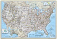 Wandkaart USA - Verenigde Staten Political, 178 x 124 cm | National Geographic
Het klassieke kaartbeeld van National Geographic, de grenzen van de staten van Amerika zijn apart gekleurd. De wandkaart is heel gedetailleerd met veel plaatsen, wegen, rivieren en nationale parken, het …
★★★★★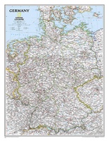 Wandkaart Germany – Duitsland, 58 x 76 cm | National Geographic
Decoratieve wandkaart van Duitsland. Naast de mooie kleuren staan er bijzonder veel plaatsen op vermeld. National Geographic's political map of Germany includes everything from country boundaries, major roads, towns …
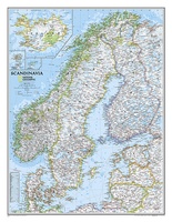
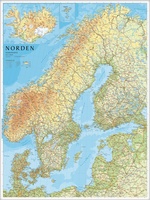 Wandkaart Scandinavië en IJsland, 75 x 100 cm | Norstedts
Prachtige wandkaart van Scandinavië met een inzet van IJsland. Hele duidelijke kaart waar door het kleurgebruik de natuurkundige aspecten als hoogte, bergen en fjorden heel goed uitkomt. Daarnaast zjin er …
★★★★★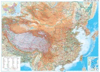 Wandkaart China – geografisch, 120 x 88 cm | Gizi Map
Prachtige wandkaart van China, waarbij zowel de politieke natuurkundige aspecten goed zichtbaar zijn. In rood zijn de belangrijkste toeristische hoogtepunten ingetekend. Kleurgebruik is vrij fel, maar daardoor wordt het geheel …
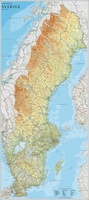 Wandkaart Zweden, 79 x 177 cm | Norstedts
Een grote kaart van Zweden voor aan de muur. Decoratieve kleuren tonen verschillende hoogten en Zweedse bergketens. Belangrijke wegen, spoorwegen en steden zijn duidelijk herkenbaar. Wordt geleverd op rol …
★★★★★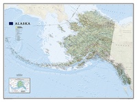 Wandkaart Alaska, 103 x 78 cm | National Geographic
Deze wandkaart van National Geographic is zeer gedetailleerd en bevat alle belangrijke plaatsen. Daarnaast is er ruimte voor de landschappelijke details zoals hoogtelijnen, rivieren, belangrijke wegen en andere items zoals …
★★★★★ Wandkaart USA - Verenigde Staten Political, 110 x 77 cm | National Geographic
Het klassieke kaartbeeld van National Geographic, de grenzen van de staten van Amerika zijn apart gekleurd. De wandkaart is heel gedetailleerd met veel plaatsen, wegen, rivieren en nationale parken, het …
★★★★★ Reliëfkaart - Wandkaart Nepal 3D | GeoRelief
Prachtig vormgegeven wandkaart van Nepal met reliëf. Uitgevoed in stevig kunststof is Nepal vanzelfsprekend een land dat zich bij uitstek leent voor een 3D kaart: zo komen de bergmassieven, maar …
 Wandkaart Scandinavië en Ijsland, 60 x 77 cm | National Geographic
National Geographic Wall Maps offer a special glimpse into current and historical events, and they inform about the world and environment. Offered in a variety of styles and formats, these …
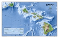 Wandkaart Hawaii, 88 x 58 cm | National Geographic
One of our most visually stunning maps, the Hawaii Physical Map shows all eight of the major islands and includes an inset of the entire chain of reefs stretching nearly …
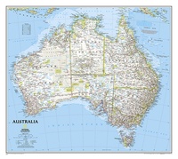 Wandkaart Australië, politiek, 77 x 60 cm | National Geographic
Highly accurate Australia political map clearly shows state boundaries, place names, bodies of water, parks and preserves, and more. Includes inset maps for Tasmania and major Australian cities.
★★★★★ Wandkaart Schotland, 76 x 91 cm | National Geographic
This new map of Scotland, features our rich, antique-inspired Executive style. This beautiful map includes thousands of place names, accurate political boundaries, national parks, archeological sites, and major infrastructure networks …
★★★★★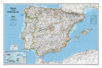 Wandkaart Spain - Spanje & Portugal 83 x 55 cm | National Geographic
This classic-style map of Spain and Portugal shows political boundaries, major highways and roads, cities and towns, airports and other geographic details. Thousands of place-names and exact borders are carefully …
 Wandkaart Britain and Ireland - Groot Brittannië en Ierland, 60 x 76 cm | National Geographic
This classic-style map of England and Wales shows political boundaries, major highways and roads, cities and towns, airports, and other geographic details. Thousands of place-names and exact borders are carefully …
 Wandkaart Ireland – Ierland, 76 x 91 cm | National Geographic
National Geographic Maps' new Ireland wall map is one of the most authoritative maps yet published of the Emerald Isle. Of the nearly 1,000 place-names shown on this map, all …
 Wandkaart Holy Land – Israël, 53 x 80 cm | National Geographic
National Geographic Wall Maps offer a special glimpse into current and historical events, and they inform about the world and environment. Offered in a variety of styles and formats, these …
 Wandkaart Afghanistan & Pakistan, 55 x 83 cm | National Geographic
This is the latest and most detailed map of the region - a perfect complement for following today's news stories. Afghanistan's 34 administrative provinces and Pakistan's provinces and territorial boundaries …
 Wandkaart Iraq – Irak, 72 x 62 cm | National Geographic
This new map of Iraq, features the classic National Geographic reference styling. Features hundreds of place names, accurate political boundaries, and major infrastructure networks such as roads, oil fields and …
 Wandkaart Korean Peninsula Noord- en Zuid Korea, 59 x 91 cm | National Geographic
Amid increasingly combative rhetoric from Pyongyang, North Korea, do you know where its underground nuclear test site or missile launch centers are located? Are you aware that the South Korean …
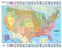 Wandkaart USA Politiek | Michelin
An annually updated political map of the USA. Beautifully coloured and laminated, with statistical information including population, surface area, state capital. Highlights the flags of each state. This laminated map, …
Waar moet je op letten als je een goede wandkaart van een land wilt kopen?
Welke verschillende soorten wandkaarten van landen zijn er eigenlijk: het kaartbeeld?
Verschillende projecties, hoe zit een wandkaart er uit?
Zijn er wandkaarten van alle landen beschikbaar?
Het formaat van een wandkaart van een land
De leesbaarheid van een wandkaart van een land
Veel uitvoeringen van dezelfde wandkaart van een land
Hoe wordt de wandkaart verzonden?
Laatste reviews

Niet echt voor beginners. Ook zijn de routes soms moeilijk qua logistiek. Weer terugkomen aan het eind bv. En in voorseizoen (mei) blijft er niet …
★★★★★ door Tjeerd 17 mei 2024 | Heeft dit artikel gekocht
Van te voren had ik een andere kaart op het oog. Toen ik in de winkel was adviseerde zij mij deze kaart. Op hun verzoek …
★★★★★ door Koen 17 mei 2024 | Heeft dit artikel gekocht
Ideale schaal waar ook de kleinere wegen duidelijk zijn aangegeven. Beschrijving op website is correct.
★★★★★ door Peter 16 mei 2024 | Heeft dit artikel gekocht
Overzichtelijke kaart. Niks op aan te merken.
★★★★★ door Bastiaan de Leeuw 16 mei 2024 | Heeft dit artikel gekocht