Winkelwagen
Geen items in winkelwagen
Ga naar winkelwagen
Wandelkaarten - Ardeche - Rhone Vallei
Overzichtskaarten
-
Wandelkaarten IGN 25.000 Ardeche - Rhone vallei Noord
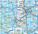

Producten op deze overzichtskaart:
Klik op een product om naar de pagina van dat product te gaan.
- Wandelkaart - Topografische kaart 2733 SB - Serie Bleue St-Anthème, Arlanc | IGN - Institut Géographique National
- Wandelkaart - Topografische kaart 2831 SB - Serie Bleue Feurs – Boën-sur-Lignon | IGN - Institut Géographique National
- Wandelkaart - Topografische kaart 2832 SB - Serie Bleue Montbrison - Veauche | IGN - Institut Géographique National
- Wandelkaart - Topografische kaart 2833 SB - Serie Bleue Firminy, St-Bonnet-le-Château | IGN - Institut Géographique National
- Wandelkaart - Topografische kaart 2834 SB - Serie Bleue Monistrol-sur-Loire, Retournac | IGN - Institut Géographique National
- Wandelkaart - Topografische kaart 2835OT Le Puy-en-Velay | IGN - Institut Géographique National
- Wandelkaart 2835OT Le Puy-en-Velay / Yssingeaux | IGN - Institut Géographique National
- Wandelkaart - Topografische kaart 2930ET Villefranche-sur-Saône | IGN - Institut Géographique National
- Wandelkaart - Topografische kaart 2931ET L'Arbresle - Monts de Tarare – Col de la Luère – Rhônevallei - Bourgondië | IGN - Institut Géographique National
- Wandelkaart - Topografische kaart 2932ET Monts du Lyonnais | IGN - Institut Géographique National
- Wandelkaart - Topografische kaart 2933ET Massif du Pilat - St-Etienne - St-Chamond - PNR du Pilat Ardéche | IGN - Institut Géographique National
- Wandelkaart - Topografische kaart 2934ET Bourg-Argental - Col de la République - PNR du Pilat Ardéche | IGN - Institut Géographique National
- Wandelkaart - Topografische kaart 2935OT Le Chambon-sur-Lignon - St-Agrève Ardéche | IGN - Institut Géographique National
- Wandelkaart - Topografische kaart 3030 Villars-les-Dombes – Villefranche-sur-Saône | IGN - Institut Géographique National
- Wandelkaart - Topografische kaart 3031OT Lyon - Villeurbanne - Mont d'Or | IGN - Institut Géographique National
- Wandelkaart - Topografische kaart 3032 SB - Serie Bleue Vénissieux, Oullins, Givors | IGN - Institut Géographique National
- Wandelkaart - Topografische kaart 3033 SB - Serie Bleue Roussillon, Vienne | IGN - Institut Géographique National
- Wandelkaart - Topografische kaart 3034 SB - Serie Bleue Serrières | IGN - Institut Géographique National
- Wandelkaart - Topografische kaart 3035 SB - Serie Bleue Tounon-sur-Rhône – Satillieu | IGN - Institut Géographique National
- Wandelkaart - Topografische kaart 3130 SB - Serie Bleue Ambérieu-en-Bugey | IGN - Institut Géographique National
- Wandelkaart - Topografische kaart 3131 SB - Serie Bleue Meyzieu | IGN - Institut Géographique National
- Wandelkaart - Topografische kaart 3132 SB - Serie Bleue Bourgoin-Jallieu - La Velpillere | IGN - Institut Géographique National
- Wandelkaart - Topografische kaart 3133 SB - Serie Bleue La Côte-St-André – St-Jean-de-Bournay | IGN - Institut Géographique National
- Wandelkaart - Topografische kaart 3134 SB - Serie Bleue St-Etienne-de-St-Geoirs – Le Grand-Serre | IGN - Institut Géographique National
- Topografische kaart - Wandelkaart 3135 Romans-sur-Isère, St-Marcellin | IGN - Institut Géographique National
-
Wandelkaarten IGN 25.000 Ardeche - Rhone vallei ZUIDELIJK GEDEELTE
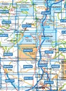
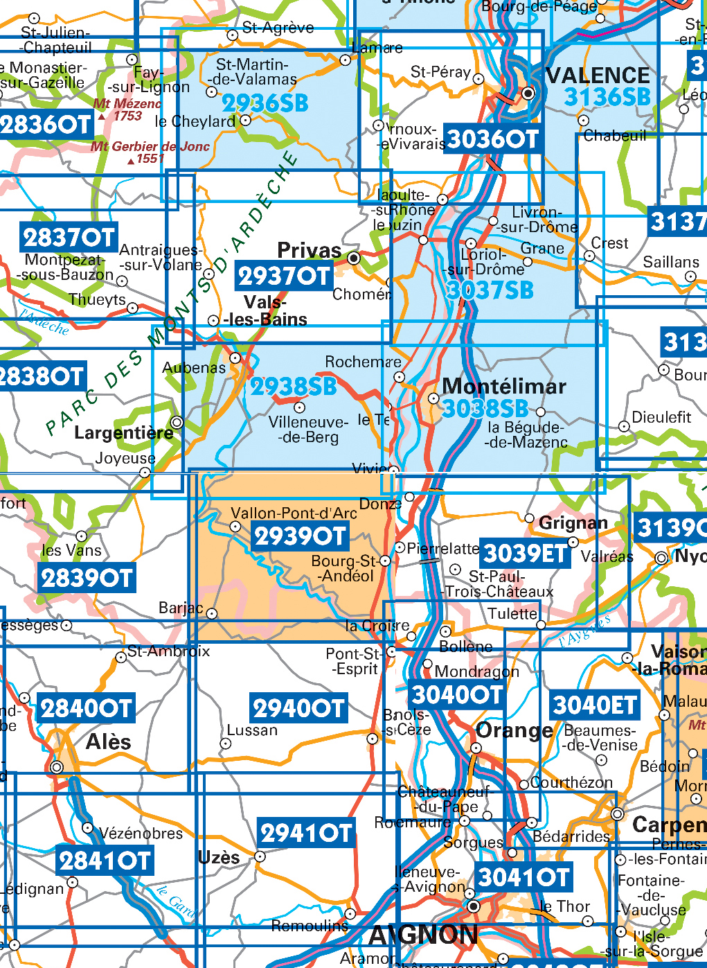
Producten op deze overzichtskaart:
Klik op een product om naar de pagina van dat product te gaan.
- Wandelkaart - Topografische kaart 2836OT Gerbier de Jonc | IGN - Institut Géographique National
- Wandelkaart - Topografische kaart 2837OT Lac d'Issarlès - Thueyts | IGN - Institut Géographique National
- Wandelkaart - Topografische kaart 2838OT Largentière | IGN - Institut Géographique National
- Wandelkaart 2839OT Bessèges / Les Vans / Vallée du Chassezac | IGN - Institut Géographique National
- Wandelkaart - Topografische kaart 2840OT Ales | IGN - Institut Géographique National
- Wandelkaart - Topografische kaart 2841OT SB - Serie Bleue Vézénobres | IGN - Institut Géographique National
- Topografische kaart - Wandelkaart 2936 SB - Serie Bleue le Cheylard | IGN - Institut Géographique National
- Wandelkaart - Topografische kaart 2937OT Privas – Vals-les-Bains | IGN - Institut Géographique National
- Wandelkaart - Topografische kaart 2938 SB - Serie Bleue Largentière, Aubenas, Villeneuve-de-Berg | IGN - Institut Géographique National
- Wandelkaart - Topografische kaart 2939OT Gorges de l'Ardèche | IGN - Institut Géographique National
- Wandelkaart - Topografische kaart 2939OTR Gorges de l'Ardèche / Bourg-St-Andéol | IGN - Institut Géographique National
- Wandelkaart - Topografische kaart 2940OT Bagnols-sur-Cèze | IGN - Institut Géographique National
- Wandelkaart 2941OT Uzès / Remoulins / Pont du Gard | IGN - Institut Géographique National
- Wandelkaart - Topografische kaart 2942OT Nîmes | IGN - Institut Géographique National
- Topografische kaart - Wandelkaart 3036OT Valence | IGN - Institut Géographique National
- Wandelkaart - Topografische kaart 3037 SB - Serie Bleue Crest – La Voulte-sur-Rhône | IGN - Institut Géographique National
- Wandelkaart - Topografische kaart 3038 SB - Serie Bleue Montélimar | IGN - Institut Géographique National
- Wandelkaart - Topografische kaart 3039ET Valréas | IGN - Institut Géographique National
- Wandelkaart - Topografische kaart 3040OT Orange | IGN - Institut Géographique National
- Wandelkaart - Topografische kaart 3041OT Avignon | IGN - Institut Géographique National
- Wandelkaart - Topografische kaart 3136 SB - Serie Bleue Bourg-de-Péage – Chabeuil | IGN - Institut Géographique National
 Wandelkaart - Topografische kaart 2841OT SB - Serie Bleue Vézénobres | IGN - Institut Géographique National
 Wandelkaart - Pelgrimsroute (kaart) 89020 St-Jacques-de-Compostela GR 65-1, St Jacobsroute | IGN - Institut Géographique National
 Wandelkaart - Topografische kaart 2735 SB - Serie Bleue Loudes, Le Puy-en-Velay | IGN - Institut Géographique National
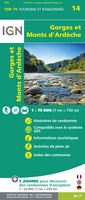 Fietskaart - Wandelkaart 75014 Gorges et Monts d'Ardèche - Ardeche | IGN - Institut Géographique National
 Wandelkaart - Topografische kaart 3037 SB - Serie Bleue Crest – La Voulte-sur-Rhône | IGN - Institut Géographique National
 Wandelkaart - Topografische kaart 3038 SB - Serie Bleue Montélimar | IGN - Institut Géographique National
 Wandelkaart Ardèche méridionale | Didier Richard★★★★★
 Wandelkaart - Fietskaart 75040 Massif du Pilat - Monts du Forez | IGN - Institut Géographique National
 Wandelkaart 2737 SB - Serie Bleue Langogne / Grandrieu | IGN - Institut Géographique National
 Wandelkaart 2839OT Bessèges / Les Vans / Vallée du Chassezac | IGN - Institut Géographique National
Laatste reviews

Duidelijke routebeschrijving met leuke informatie over omgeving
Tot nu toe één stuk van de route gelopen. De route was duidelijk met leuke informatie over de plekken waar doorheen of langsgelopen werd. Het …
★★★★★ door Dana 29 maart 2025 | Heeft dit artikel gekocht
heel fijne kaart
ik ben erg tevreden met mijn aankoop bij de zwerver, het was heel snel geleverd en de kaart is top
★★★★★ door luc van Esch 28 maart 2025 | Heeft dit artikel gekocht
Mooi boek - snel geleverd!
Informatief boek, keurig en snel geleverd!
★★★★★ door World Explorers 28 maart 2025 | Heeft dit artikel gekocht
Handig
Heeft een duidelijk beeld van alle eilanden waardoor het makkelijk kiezen is
★★★★★ door Carla Van Den Eeckhoudt 28 maart 2025 | Heeft dit artikel gekocht